National Parks in South America from 1872

On March 1, 1872 the United States Congress passed an act establishing Yellowstone in Wyoming as the first national park. It was not the first time a government had enclosed an area through legislature, but it was the first time a government had designated an area as a ‘National Park.’ In describing the geographical boundaries of Yellowstone, the 42nd Congress wrote that the land was “… hereby reserved and withdrawn from settlement, occupancy, or sale under the laws of the United States, and dedicated and set apart as a public park or pleasuring-ground for the benefit and enjoyment of the people…” Yellowstone would be the first of an eventual sixty-three National Parks that would be created across the American continent. Although Mary Stuckey argues in her book For the Enjoyment of the People: The Creation of National Identity in American Public Lands that the development of mostly Western lands into parks were part of an effort to further dispossess Indigenous peoples of their lands and legitimize these claims through legislature, National Parks were publicly created to conserve visually impactful landscapes. As the Organic Act of 1916 states regarding the creation of the National Park Service, “the Service thus established shall promote and regulate the use of the Federal areas known as national parks, monuments and reservations … which purpose is to conserve the scenery and the natural and historic objects and the wild life therein and to provide for the enjoyment of the same in such manner and by such means as will leave them unimpaired for the enjoyment of future generations.” Despite the forty-five year gap between the creation of Yellowstone and the bureaucracy that governs it, the general purpose to “conserve visually impactful landscapes” is the backbone for the thirty-five parks created in that era and to the present.
Within the same decade that the United States legislated the creation of Yellowstone, many South American countries began endeavors of their own to conserve landscapes within their nations. But the reasons for conserving land and unifying those lands under a legislated parks office vastly differed among each country, although an underlying reason for most countries was to secure frontier lands with national claims.1 Waklid further elaborates that the late nineteenth to early twentieth century represented a “significant era of conservation … as a response to concerns over degradation combined with a curiosity about the notion of protecting lands with justifications [including] elite ideas about scenery and tourism potential [and] suggestions of the need for scientific study”.2 Waklid establishes this common thread as a generalized approach to the formation of national parks in Latin America but looking further into the specific details and contexts of certain countries’ histories of their parks and systems, the reasons for creation are a lot more nuanced–and frankly fascinating–than scenery and tourism. Those two reasons form the backbone for the American system of parks but frames Latin American within the North American understanding of conservation, recreation, and landscapes.
This project hopes to establish a deeper understanding of the development of national park systems in Latin America in the century after the creation of Yellowstone in 1872 by mapping early parks in Argentina, Brazil and Colombia and exploring their spatial and bureaucratic origins.
The spatialized basis for this project lies in the World Database for Protected Areas (WDPA), a “joint project of UNEP and the International Union for Conservation of Nature (IUCN) compiled and managed by the UN Environment Programme World Conservation Monitoring Centre (UNEP-WCMC), in collaboration with governments, non-governmental organisations, and other data-providers. The WDPA is the most comprehensive global database of marine and terrestrial protected areas, comprising both spatial data (i.e. boundaries and points) with associated attribute data (i.e. tabular information).“3 Officially established in 1981, the WDPA actually began in 1959 when the UN Economic and Social Council “called for a list of national parks and equivalent reserves in recognition that they ‘are valuable for economic and scientific reasons and also as areas for the future preservation of fauna and flora and geologic structures in their natural state.“4
The database is updated monthly and available for geographic information system (GIS) software.
Argentina
Argentina’s National Park system came into existence at the beginning of the twentieth century, laying down the foundation for the first national parks in South America. French-Argentine landscape architect Carlos Thays conducted a study and designed a plan for the establishment of the system, starting with Iguazu Falls. The next year, 1903, Judge Francisco Moreno donated over 18,500 acres with his wishes being that the land be consecrated as a public national park. Over the next twenty years the park’s territory was gradually increased and a presidential decree officially deemed the park part of the Argentine system. In 1923 Belgian botanist Lucien Hauman created a list of lands worth conserving which would help the government further develop their park portfolio. Iguazu Falls finally began development in 1928 when 75,000 hectares of land were bought for parkland and a military base. But it wasn’t until 1934 that the General Administration of National Parks and Tourism was created, along with Iguazu and Nahuel Huapi, by the government. During the first decades of existence the primary objective of the agency was to protect pristine nature, defend borders, and promote high level tourism. International tourism was highly instrumental in furthering the agency, but a large amount of support also came from Argentine park-goers. In more recent years, the organization has focused on new types of conservation units that prohibit any public use called ‘strict preserves’ and has also introduced ‘Defensive Natural Reserves‘ in collaboration with the armed forces to provide responsibly managed training ranges.
This is a condensed and translated version of Argentina’s National Park system history. The full untranslated text can be found here.

Parque Nacional El Rey

Parque Nacional Nahuel Huapi

Parque Nacional Iguazú

Brazil
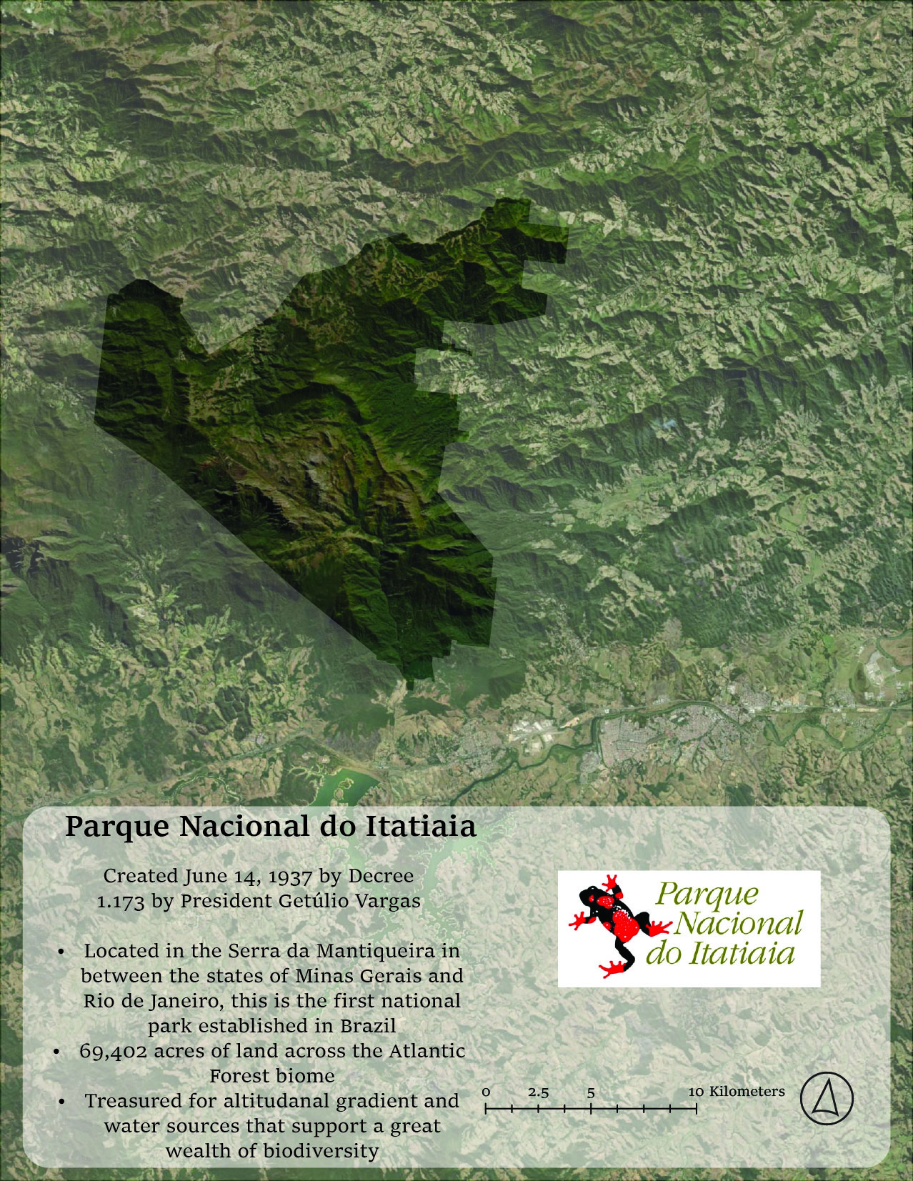
Brazil’s first National Park, Itatiaia, was legislatively created on June 14, 1937 when President Getulio Vargas signed Decree Nº 1.713 which states :
[T]hat this location simultaneously protects nature, aids natural sciences, increases tourist flows and preserves existing forests for future generations, that is, all the objectives, combined simultaneously, that justify the creation of National Parks.
Article One of the decree declares Itatiaia Biological Station, an extension of the Rio de Janeiro Botanical Garden, and all lands, flora, and fauna within being subject to the decree. The rest of the articles of the decree deal with the staffing, aggrandizing, and future management of the park. One particular moment of this piece of legislation that is particularly interesting is the fact that commission is called for to plan for the organization of the park composing of members from the Highway Service, Ministry of Transport and Public Works, National Department of Cultural Propaganda, Ministry of Justice, the Rio de Janeiro Botanical Garden, Ministry of Agriculture and Federal Forestry Council. The bringing together of all these offices shows a unique understanding of conservation and laid the base for what would become the National Park system of Brazil. Itatiaia and subsequently Serra dos Órgãos were created for the large population of Rio de Janeiro and neighboring cities to visit often as they are easily accessible to the residents. Iguaçu, much like its Argentine counterpart, was far from populations and was created, among other reasons, to secure national borders by providing national land to military forces.5 In later years attention turned to conserving large swaths of Amazon Rainforest as deforestation became an international concern. Today the Brazilian park system is rather decentralized with states managing parks in their borders or parks managing themselves or through partnerships. The Chico Mendes Institute for the Conservation of Biodiversity, an autonomous agency under the Ministry of Environment, which manages all conservation units in the country.
Parque Nacional do Iguaçu

Parque Nacional da Serra dos Órgãos

Parque Nacional do Itatiaia
Colombia
The formation of Colombia’s National Parks and managing system is more inconsistent and nonlinear than Argentina and Brazil. The earliest conservation lands were created in 1948 when Sierra de La Macarena was cordoned off at the behest of the Colombian Health and Hygiene Minister for research into yellow fever in the southwest forests. Cueva de los Guácharos was also created for the protection of the guácharo, or oilbird, which was being hunted for their oil. A professor for the most important private school in Bogota utilized his political connections to pass legislation to protect the cave and surrounding forest. Farallones de Cali was established by the Department of Valle del Cauca after trying to protect the headwaters for Cali’s water supply for over three decades.

It was later incorporated into the national park system when the Colombian Institute for Agrarian Reform was authorized to conserve landscapes to protect natural resources. It would be this organization that would merge with the Ministry of Agriculture to form the National Institute of Natural Renewable Resources in 1968 to manage the small number of parks. The gap in development of national parks and conservation land is due to the fact that the country was incredibly destabilized from 1946-1958 during a period known as La Violencia. Although early parks had a wide range of reasons for their creation, Parks from the 70s onwards were more inline with international regulations regarding conservation.
This is a condensed and translated version of Colombia’s National Park system history. The full untranslated text by Claudia Leal can be found here.

Parque Nacional Sierra Nevada de Santa Marta

Parque Nacional Farallones de Cali

Parque Nacional Cueva de los Guacharos

- Emily Waklid. A Panorama of Parks in A Living Past: Environmental Histories of Modern Latin America. (New York: Berghahn, 2018), 254. ↩︎
- Ibid. ↩︎
- UNEP-WCMC User Manual for the World Database on Protected Areas and world database on other effective area-based conservation measures: 1.6 (Cambridge, England: UNEP-WCMC, 2019), 7 ↩︎
- Ibid. ↩︎
- Freitas, Frederico. “A Park for the Borderlands: The Creation of the Iguaçu National Park in Southern Brazil, 1880-1940*.” (2014). ↩︎
Spatial Data Sources